
MassWateR is a package of R functions that has been developed to help water quality monitoring organization in Massachusetts manage their data. It provides tools and templates for conducting quality control of water data, analyzing water data, and submitting data to the centralized EPA WQX database. It was developed under the direction of the Massachusetts Bays National Estuary Partnership by a team made up of Marcus Beck (Tampa Bay Estuary Program), Jillian Carr (Mass Bays), and Ben Wetherill (ACASAK Consulting).

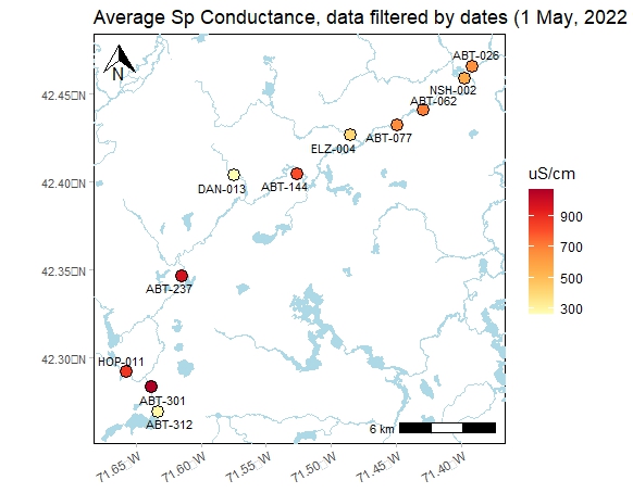
I have been providing water quality monitoring technical and analytical support to the Wayland Surface Water Quality Committee for their long-term study of water quality in Dudley Pond. They have been monitoring water quality in the pond since 2011 in an attempt to understand nutrient and chlorophyll levels in the pond and develop a management plan for controlling underwater vegetation. I am working together with volunteers from the Committee to monitor water conditions and analyze relationships and trends of water quality parameters.
SeaTrac Plymouth Bay and Salem Sound
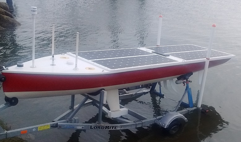
I have been supporting a joint project with Mass Bays and SeaTrac to test the water quality monitoring capabilities of SeaTrac's autonomous vessel. In Plymouth Bay and Duxbury Bay, Mass Bays is interested in studying changes in water quality that could help explain the losses of eelgrass that have occurred over the last 60 years. In Salem Sound, together with Salem Sound Coastwatch, they are interested in studying the effects of two sewer outfalls on the Sound. SeaTrac's autonomous vessel was outfitted with a multi-parameter sonde and then programmed to autonomously navigate the bays collecting continuous water quality data.

Save the Harbor/Save the Bay asked me to install rain gauges and sewer flow sensors to better understand the factors that affect water quality on the Boston Harbor region's public beaches. This specific project included continuous monitoring of the sewer outfall at King's Beach and frequent water sample collection and analysis from the beach swimming area.

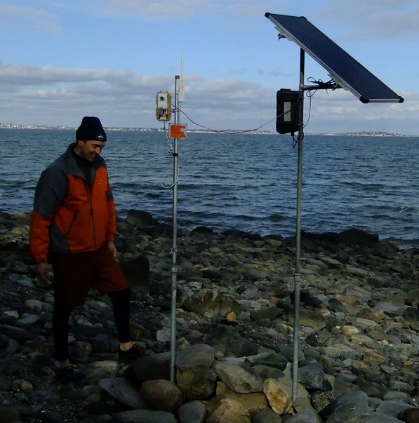
A weather and water temperature monitoring station was installed on an island in the Charles River for the Charles River Watershed Association (CRWA). The station provides real-time weather and water temperature data for anybody to use, and it is used by CRWA to feed hourly data into an online model that predicts water quality for recreational boating. This water quality forecast is used by the large community of boathouses on the Charles to make decisions about river use. This project was part of my Master's thesis on the value of real-time environmental sensor networks. It was funded by MIT Sea Grant and supported by the UMass Boston Center for Coastal Environmental Sensor Networks.

Wireless video cameras were installed in a salt marsh in Essex Bay, MA for investigators from Mass Bays and Boston University. The cameras were used to monitor invasive green crab activity. There is a concern that green crab burrows are exacerbating salt marsh erosion. With the threat of sea-level rise, salt marshes are already at risk, so the compounded impact of green crab burrowing could be considerable. This project used two video cameras to capture real-time imagery with high temporal resolution of crab activity and marsh bank changes. A daylight-only camera provided a wide-angle view of the marsh bank, and a second camera with nighttime infrared capability was focused at close range at the edge of the marsh bank during low tides. Both cameras were deployed for over a year starting in summer 2015.
During the winter, the cameras were focused on studing the role of ice in destabilizing marsh banks. Ice wedges in cracks on marsh banks are an interesting phenomenon that has been assumed but not studied in detail. The high-resolution camera images helped understand this natural forcing.
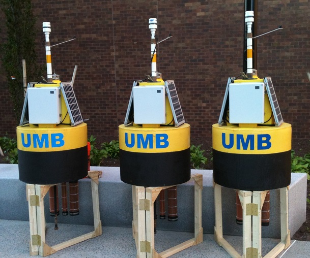
In a project led by the Center for Coastal Environmental Sensing Networks (CESN) at UMass Boston, three custom water chemistry monitoring buoys were designed and built for Boston Harbor. The buoys measure water temperature, salinity, chlorophyll, turbidity, cdom, and a full array of meteorological parameters every 10 minutes, and data is uploaded via cellular telemetry to a web server on an hourly basis. These buoys were constructed as part of an MIT SeaGrant and MWRA funded project to develop correlations between satellite imagery and water quality parameters. The buoys are intended to be deployed permanently during ice-free months. Data from the buoys is made public through the CESN website.

Two wireless video cameras were installed for the Jones River Watershed Association to monitor salt marsh erosion in the Jones River. The Jones River Watershed Association in a joint project with MIT SeaGrant is studying the effect of sea level rise on coastal salt marshes. Both cameras were deployed for several years to capture long term changes as well as instantaneous events. These cameras were copies of the cameras developed on Thompson Island.
In coordination with the BU Multimedia Communication Laboratory and the UMB Center for Coastal Environmental Sensor Networks, a network of wireless video cameras was deployed on Thompson Island in Boston Harbor to monitor long-term erosion of the northern bluff and other coastal processes along the eastern side. This installation served two purposes. It was a test to see how well low cost video cameras on a long-distance wireless network could perform in a harsh coastal environment. And it was intended to be a resource for the Thompson Island Outward Bound Education Center. The successful completion of the test spawned contracts for other camera installations in the Jones River Marsh and Essex Bay which have both been used to support serious scientific research. The Thompson Island organization is dedicated to educating school children in outdoor experiences and environmental science. The images gathered from this camera were used as an exhibit in the education programs run on the island.